Manufacturing.Net - March 04, 2011
Announcement of Data Release Glacial Lake Inventory of Bhutan using ALOS (Daichi) Data
The Japan Aerospace Exploration Agency (JAXA) is cordially announcing public release of "Glacial Lake Inventory of Bhutan using the Advanced Land Observing Satellite (ALOS, nicknamed "Daichi") Data" (evaluation version). In the Himalayan region, there are numerous lakes in the vicinity of glaciers. These glacial lakes impose potential risks for sudden outbursts and consequent floods. This type of flooding event is referred to as a glacial lake outburst flood (GLOF), which occurs frequently enough in the Himalayan region. With a growing amount of public and scientific concern about hazards, climate change, and water management associated with GLOFs, the "Bhutan GLOF Project" (*1) aims at updating and improving glacial lake inventory for Bhutan using new and high spatial resolution data from ALOS. The motivation for this release is to support the research community and various domestic and international projects. By releasing the evaluation version, we hope to collect comments and suggestions for the preparation of the full release of the inventory, now scheduled in the spring of 2012.
The inventory is based on images taken between 2006 and 2011 from the two optical instruments, the Panchromatic Remote-sensing Instrument for Stereo Mapping (PRISM) and the Advanced Visible and Near Infrared Radiometer type 2 (AVNIR-2) onboard ALOS. The construction procedure consists of ortho-rectification, geometric correction, pan-sharpening, and digitization to extract water bodies. Glacial lakes included in the inventory are bodies of water that lay between the terminus of the mother glacier and the Little Ice Age moraine. Lakes located within 2 km of the Little Ice Age moraine down-valley are also included to take into account a possible flooding event with multiple lakes being involved. In addition, supraglacial lakes on debris-covered glaciers are included. Finally, we set 0.01 km2 as the minimum lake size considering small lakes contribute a less amount of GLOFs' risk. For this release we selected the Mangde Chu sub-basin, located in the central Bhutan. The parameters included in the inventory are ID, latitude, longitude, area, length, width, and some references in addition to a shape file for each lake. There are 93 glacial lakes in the Mangde Chu sub-basin.
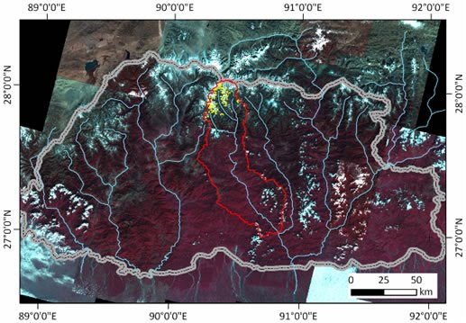
Figure 1 shows the pan-sharpended image covering Bhutan overlaid the glacial lakes inventory (yellow polygons), Mangde Chu sub-basin (red line) and the Bhutanese border (gray line). Figure 2 provides the detailed image over Metathota glacial lake (yellow polygons) with ground truth data by GPS measurements in 2010 (green line). The red polygons indicate existing inventory provided in 2000.
*1 The project is a collaborative work of Nagoya University, Rikkyo University, Hokkaido University, National Research Institute for Earth Science and Disaster Prevention (NIED), Hiroshima Institute of Technology, Japan Agency for Marine-Earth Science and Technology (JAMSTEC), Remote Sensing Technology Center of Japan (RESTEC), Niigata University, Research Institute for Humanity and Nature (RIHN), Earth System Science Co.,Ltd. (ESS), Hirosaki University, Nihon University, Teikyo Heisei University, Gunma University, Keio University and the Department of Mineral and Geology (DGM) of the Royal Government of Bhutan supported by the Japan Science and Technology Agency (JST) and the Japan International Cooperation Agency (JICA) under the "Science and Technology Research Partnership for Sustainable Development" (SATREPS).
Link to the Inventory
http://www.eorc.jaxa.jp/ALOS/en/bhutan_gli/index.htm (in English)
http://www.eorc.jaxa.jp/ALOS/bhutan_gli/index.htm (in Japanese)

