Keeping in mind the election and fear of being marginalized in politics thepeople in the power are drawing new maps for constituencies.
New dzongkhag, gewog boundariesPosted on Wednesday, June 21, 2006, @ 09:04:04 EDT
National Assembly: 21 June 2006- With an executive order from the Prime Minister's Office endorsed by the National Assembly on June 19, gewog and dzongkhag boundaries have been changed across the country.
According to the minister for home and cultural affairs, Lyonpo Jigmi Yoezer Thinley, the exercise was undertaken for the 2008 electoral process as well as for the convenience of the people. He said that it was time to rationalise the boundaries since most of the present demarcation did not have any economic and sociological benefits.
He said that the improper demarcations administratively did not stand to reason. For instance, a village in the middle of Limukha under Punakha dzongkhag belonged to the Babesa gewog, Thimphu dzongkhag.
Chimis submitted varying views on the executive order. The chimis from Zhemgang and Punakha said that the decisions would be acceptable to the people. Punakha chimi Namgay Phuntsho said that the government would have made such a decision only after extensive deliberations and disputes could be discussed at the Dzongkhag Yargay Tshogdu (DYT) and the Gewog Yargey Tshogchung (GYT) levels.
The Bumthang chimi submitted that the decision for the new demarcations should have been routed through the DYT and GYT in keeping with the decentralisation policy. “There are cultural and social problems that we need to look into at the grass root level,” he said.
Lyonpo Jigmi Thinley told Kuensel that some families would be affected but it had to be done in the larger interest of the people. “There is also demographic considerations,” the home minister told Kuensel. “For example, bigger gewogs like Orong, in Samdrup Jongkhar, which has about 7000 people will be divided into two geogs which means that they will receive twice as many facilities. We have consulted the people, at all levels, for the last 21 years and if we give it back to the people for discussion it will never be decided because a lot of sentimental issues will come in.”
He also said that all decisions with regard to the demarcation should be finalised by the end of 2006 since the electoral constituencies had to be based on the new boundaries.
“If present inconveniences are not solved today, then there would be a lot of problems in 2008 with the electoral process,” he said.
According to the executive order the transfer of sa-thram and census resulting from the new demarcations should be done by October, 2006, and a report on the exercise should be submitted to the Lhengye Zhungtsho by the end of October, 2006.
The executive order also states that the exercise was carried out by the home, agriculture, and the work and human settlement ministries as per the resolutions of the 84th National Assembly session. The finalised demarcations were then submitted and discussed by the Lhengye Zhungtsho.
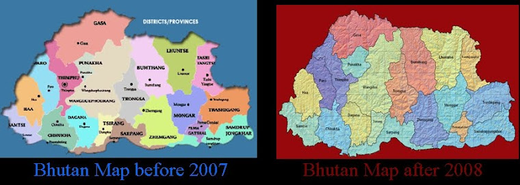
There are changes in the demarcations for all dzongkhags apart from Bumthang, Lhuentse, Trashiyangtse, Gasa, Dagana and Tsirang.
The new boundariesNaja village, with 61 households under the Naja geog in Paro, will be merged with Paro's Sharpa geog.
The villages of Rangzhigang, Chortengang, Wanakha, Bachim and Tseji, that are located on the left bank of the Hachu and belonged to Chukha dzongkhag, will now fall under the Naja geog of Paro. The five villages have a total of 110 households and 1,300 people.
Dongkarla, Bemrilhakang and the Jela dzong mountains will be the boundary between the Paro and Thimphu dzongkhags.
Ninety-nine houses with 769 people located on the right banks of the Jemi stream and Wangchu will be merged with Mewang geog in Thimphu. Of the 99 families, 37 are under Hungrel geog, 51 under Dokar, and 11 under Dhopshari geogs which are all under the Paro dzongkhag.
The present Basesa geog of Thimphu, on the right bank of the Punatsangchu river, will be created as a new geog under Punakha dzongkhag.
The four households in Limukha village which was under the Babesa geog, Thimphu, will be merged with the Limukha geog in Punakha.
The three villages of Wangjo, Martorlungchung, and Bajothangu, with 44 households and 331 people, located on the left banks of the Punatsangchu river, which belonged to the Babesa geog, will be merged with Thaytsho geog, Wangduephodrang dzongkhag.
Twenty-two villages falling between Dochula and East of Sichula in Toebi geog, Thimphu, will be created as a new and separate geog in Punakha dzongkhag. The new geog will have 304 households with 2,526 people.
From Dochula towards Thimphu, the three villages of Tashigang Goenba, Hongtsho and Yusipang, with 45 households, will be in Thimphu dzongkhag under Chang geog.
Bajodurshingphu has been identified as the boundary demarcation between Trongsa and Sarpang dzongkhags. The villages of Raytee and Dodari under Korphu geog in Trongsa will be merged with Sarpang dzongkhag's Jigmecholing geog.
The Manas National Park under Taklai geog will be merged with Zhemgang dzongkhag.
The Sangkhu village in Lhamoizhingkha geog, Sarpang with 57 households and 318 residents will be merged under Darla geog, Chukha.
Ten villages with 416 households and a population of 3,875 under Decheling geog in Nanglam dungkhag, Samdrup Jonkhar and 13 villages with 582 households and 5,365 people under the same dzongkhag will be created as two new geogs under Pemagatshel dzongkhag.
The Nanong geog in Wamrong dungkhag, Trashigang, will be merged with the Pemagatshel dzongkhag.
Four villages with 49 households and 551 people located at the right bank of the Amochu river under Dungtey geog, Samtse and four villages under the Lhareni geog with 25 households and 134 people will be merged with the Haa dzongkhag, under Sangbay geog.
On the left bank of the Amochu river, some of the villages under Samtse dzongkhag's Mayona, Samar and Sangbay geogs and villages falling from the top of Tegor La and Salay La and upward of the Sumchugang will be created as a new geog under Haa.
A new geog will be created from Mayona geog's five villages of Phentayna, Segtayna, Saijong, Thangdokha, Ngachey which together have 85 households and a population of 1068. An additional eight households with 85 people from Yangtsay village under Sangbay geog and 25 households with 350 people from Samar geog's Dorithagsa's village will be included in the new geog. The rest of the households of Mayona geog's five villages will be merged with Samtse's Denchukha geog.
The Dremitse geog in Mongar will be divided into two geogs namely Dremitse and Narang geogs. Under the Dremitse geog there will be 10 villages, 350 households and 3,070 people and Narang geog will have five villages, 205 households and 1,664 people.
The Orong geog in Samdrup Jonkhar, which has 833 household and 7,513 people, will be divided into two geogs. With the division, the new Orong geog will have 466 households while the new Dewathang geog will have 367 households.
The Gomdar geog in Samdrup Jonkhar will also be divided into Gomdar and Wangphug geogs. Of the prevailing 31 villages with 888 households and 7,405 people, the new Gomdar geog will have 19 villages with 548 households and Wangphug geog will have 12 villages and 340 households.
By Kinley Y Dorjikins@kuensel.com.bt
The Sorry Saga of Bhutan's North
Click over the map to know the differences
No comments:
Post a Comment